

Geospatial and Geographic Information Systems
Geospatial and Geographic Information Systems (GIS): Want to get involved?
When you hear the words “geospatial” and “GIS’, what comes to mind? Many people think the terms are interchangeable. But there’s actually a bit of nuance beneath the surface.
At the most basic level, both terms refer to the tools and techniques used to map geographic locations. However, the way they’re used can vary somewhat.
Find out more in the article by GISGeography.
What is GIS?
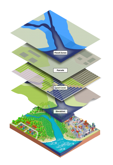
GIS (Geographic Information Systems) is the integration of spatial and non-spatial data using geographic software to store, analyze and visualize data.
People use GIS to create maps, graphs, diagrams, and charts that can help them visualize processes, outcomes, and other information.
While GIS can be used to create maps, it’s best known for its ability to process spatial data and analyze data about locations, like where things are located or how they’re connected.
What is Geospatial?
Geospatial, on the other hand, refers to the context of how data is associated with a particular location or geographic coordinate.
A simple example is using Google Maps to track the location of different addresses. Each location represents geospatial data because it relates to the mapping of places.
The term “geospatial” is a catch-all term with a broader scope for technology. But it always includes a location-based component.
This can include everything from GPS receivers, remote sensing, and LiDAR software.
Spatial vs Geospatial
Spatial and geospatial data have many parallels. But the term “spatial” has an even broader scope, which includes anything in physical space with or without coordinates.
For example, spatial orientation is the process of identifying your location, where you are in relation to your surroundings, and the distance and direction between where you are and where you want to be.
From driving a car to navigating unfamiliar terrain, spatial awareness is a process that is crucial for a wide range of activities and everyday life.
But in the field of GIS, there are no differences between “spatial data” and “geospatial data”. Similarly, “spatial analysis” and “geospatial analysis” are generally equal terms.
Get involved in Geospatial / GIS activities to explore more...
***Interested in CAP's innovative Geospatial programs? Find out about Geographic Information Systems (GIS) - related programs:
-
United States Geospatial Intelligence Foundation (USGIF) K-12 Education Resources
-
America View: Empowering Earth Observation Education K-12 Resources
Coming UP? 13-17 November 2023
National Geographic's Geography Awareness Week Educational Ideas for preK-12+ (Celebrated each November)
Try out these cool links: